Askja is a caldera in a central volcano situated in Iceland’s remote interior highlands. The name also refers to a dramatic ring of nested calderas in the surrounding Dyngjufjoll Mountains.
The word “askja” is Icelandic for “caldera.” Calderas are sunken, cauldron-like craters that form when land collapses following a volcanic eruption. Most calderas resemble volcanic craters.
Askja stands in the Odadahraun lava field, a vast desert-like wilderness covering 5.000 km2 (1.930 sq. miles). A small amount of fertile areas break up the desolate landscape. Askja and Odadahraun are part of Vatnajokull National Park.
The Dyngufjoll mountains emerged in eruptions under an Ice Age glacier cap. Askja itself formed at the end of the Ice Age. A major ash eruption caused the central volcano’s magma chamber to collapse and subside. A deep circular depression remained that gradually filled with lava from subsequent eruptions.
The last eruption took place in 1961. However, Askja is still active, and its base is still gradually sinking. Askja is certainly alive and kicking, and it will continue to remind people that Iceland is still forming.
The bottom of Askja is currently at an altitude of 1.100 m (3.609 ft) while the rim is 1.300-1.500 m (4.266 – 4.921 ft) above sea level. The lower slopes of Askja are covered with rough lava.
NASA and Askja
The landscape surrounding Askja seems like an alien planet, thanks to desert-like conditions, ash and lava. Actually, the NASA Apollo program used the area to prepare astronauts for their lunar mission. NASA believed the landscape and geology might be similar to that of the moon. In 2015, some of these astronauts revisited Askja.
The Explorer’s Museum in Husavik village has interesting information about the NASA visits to Askja.
Lake Askja
Lake Askja is Iceland’s deepest lake with a depth of more than 200 m (656 ft). It formed in 1875 when a powerful eruption occurred in the south of the caldera. Almost 2.5 cubic km (.6 cubic miles) of volcanic material surged up from the vent in just a few hours. After the eruption, the magma chamber ceiling began to subside, eventually stopping almost 250 m (820 ft) below its initial level. The depression filled with ground water, forming Lake Askja.
Between 1922 and 1929, several small eruptions occurred around the edge of the new depression.
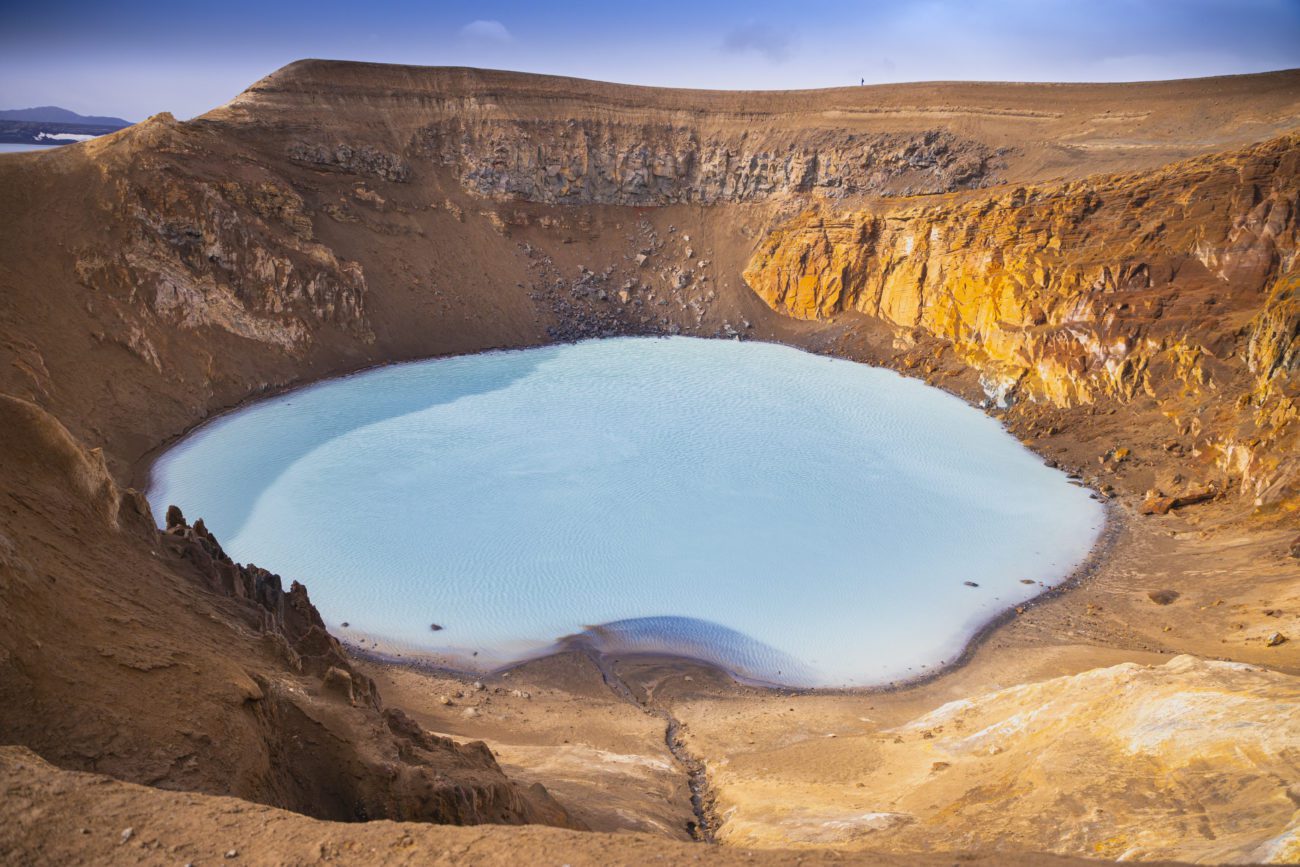
Viti – a warm crater lake
In fact, the caldera contains several volcanoes, including Viti, formed at the end of the 1875 eruption. Water has accumulated in the crater. Its temperature changes, depending on how much glacial meltwater enters the crater. On average, it is around 30°C (86°F). The water is deepest at the crater’s center, more than 8 metres (26 ft).
Viti is a popular bathing site, but if you intend to take a dip, please be aware that the sloping path is very slippery in wet weather. The mud at the bottom is quite hot, especially on the eastern bank. There is also a danger of rocks falling from the edges.
Visiting Askja
Please note that the volcano is only accessible for a few months of the year, due to snow and weather. The roads around Askja are unpaved and rugged F roads. Therefore, you must have a 4WD vehicle with a high undercarriage. We recommend you first stop at Drekagil’s park ranger station so you can find out the latest travel conditions at Viti crater. Drekagil is also a wonderful place to spend some time hiking among the bizarre lava formations.